
If one thing that is becoming increasingly clear, is that climate change is real. As the earth gets warmer, scientists around the world are observing dramatic and series changes . These changes may have serious consequences. A stark rise in the sea level is one such phenomenon.
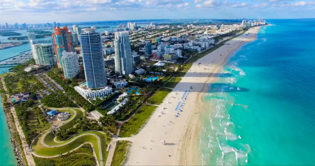
One-quarter to half of Florida may be underwater by 2100. Climate change, geographical location, and local weather phenomena make Florida more susceptible to climate change. Florida is also at an increased risk of flooding, hurricanes, agricultural damage, and contamination of freshwater aquifers.
In this article, I’ll discuss why the sea levels are rising at a faster rate, especially in Florida. I’ll also look at which areas in Florida are at most risk, disaster predictions, and what the government is doing to tackle sea level rise in Florida.
Global warming and sea level rise
Global warming is the phenomenon by which there is a striking rise in the earth’s temperature due to human-induced causes, particularly the use of fossil fuels. When we burn fossil fuels (like coal, oil, and gas), greenhouse gases like carbon dioxide and methane are released into the atmosphere.
These gases rise to higher levels of the atmosphere and form a thick blanket around the earth. This blanket acts like a greenhouse, trapping the heat of the sun. This increases the temperature of the earth, which can melt ice-caps and glaciers and lead to sea level rise.
How sea level rise will affect Florida
Climate change-induced sea-level rise is increasing. Scientists have shown that the sea levels have been increasing at a rate of 3 millimeters per year along the US Atlantic Coast. This is twice as fast as the increase in sea level compared to the last century.
If this trend continues, scientists predict a rise of up to 1 meter (3.3 feet) in the next hundred years. This will likely lead to devastating consequences, particularly in low lying areas including Florida.
But why Florida?
The geographic location of Florida is what makes it so vulnerable to the rise in sea level. The state has a long coastline of 1350 miles and a mean elevation of only 100 feet. In fact, many places in Central and South Florida are located exactly at sea level. Most parts of inland Florida and the north are at a higher level, making them less susceptible to significant inundation and damage. However, southern Florida is a high risk for flooding.
This is also the reason why other states in the continental US are unaffected. Other coastal regions north of Florida and on the Pacific coast, all have a higher mean state elevation. While this does not mean that they will be completely safe from rising sea levels, they are less at risk when compared to Florida.
Another factor to consider is location-specific effects like El Nino and the North Atlantic Oscillation. These weather phenomena have now been linked to the more local rise in sea levels around the Atlantic Coast, particularly around Florida. In fact, a Forbes report shows that Florida’s sea levels rise six times faster than other regions – independently of climate change. This is a direct consequence of these local weather phenomena.
Areas of Florida that will be most affected
Most parts of North and Central Florida are relatively safe. As we move towards the peninsula and the Gulf, we come across more vulnerable counties.
The most critical regions that may suffer from even a sea-level rise of a few millimetres (5/64″) include:
- Key West,
- parts of Miami,
- Fort Lauderdale,
- Daytona Beach,
- Jacksonville,
- Cape Canaveral,
- Saint Petersburg,
- Fort Myers,
- Pensacola,
- Panama City, and
- Tallahassee.
A First Coast news report states that Jacksonville might see dangerous 100-year floods in less than 30 years.
The most AT RISK counties include:
- Miami-Dade,
- Broward,
- Palm Beach,
- Lee,
- Sarasota,
- Collier,
- Manatee,
- Monroe,
- Pinellas, and
- Charlotte.
This is worrisome because these counties form part of the metropolitan regions of Florida and house around 10 million people. This is almost half the population of the state.
Risk factors in these locations
These vulnerable counties contribute to the economic development of Florida. In every county mentioned above, most of the people live within a few miles of the coast, and coastal development in Florida is rampant.
Inland Florida is home to the Everglades and a number of estuaries. Not everyone in Florida wants to live in the Everglades and environmental protection laws are strict here, which means any development is scarce.
Coastal development in Florida barely extends over 20 miles from the coastline. From Miami and Tampa to Palm Beach, the most developed regions of Florida have a population density of more than 10,000 people per square mile. This is higher than Los Angeles!
These strips of developed land are built right on the coast and are typically only 5-10 miles wide. Although Florida is a densely populated state, most of the population lives and works in low-lying coastal areas. This puts many people at risk from sea-level rise causing inundation, increased storm surge, coastal erosion and, eventually, relocation, as an NBC report showed.
Experts think that Miami is currently being developed “like there is no tomorrow”, which will put more people at risk as we move into this new 21st-century climate.
What this means for Florida
A rise in sea level will undoubtedly have devastating consequences for it’s people, infrastructure, and natural ecosystems.
High sea levels imply an increased risk of flooding, particularly during the spring and summer. High tides and onshore winds can contribute to flooding. This may force millions of people to relocate to safer, higher ground. Not only will this cause a loss to life and property, but this will cripple the GDP of the metropolitan areas of Florida.
A building collapse in June 2021 was the latest wake-up call that scientists used to warn residents about the effects of rising sea levels.
Higher sea levels also increases the risk of tropical hurricanes. Since seas are usually rough around the region (particularly about the effects of El Niño), even initially small hurricanes may be bumped up to a Category 5 as they reach the shore.
In this case, storm drains will not be too helpful either. Since most storm drains work on the principle of gravity, they will not be effective in low-lying areas where the sea level is already too high.
Florida is the fourth largest contributor to the GDP of the United States, after California, New York, and Texas. A natural calamity will shatter the economy and lead to grave financial consequences.
South Florida, the most vulnerable region, contributes to 60% of the GDP of the state.
With increased risks of flooding, the tourism sector will also take a hit, leading to reduced income for the locals. It is estimated that it would take USD $8 billion just to temporarily restore damaged beaches.
Increased sea levels will also cause insects, pests, and weeds to migrate up north. This directly affects agricultural regions and may destroy crops. Infestations of weeds and insects cost millions of dollars to manage.
What about Florida’s freshwater aquifers?
In addition to an increased risk of flooding, another critical issue is that of underground freshwater aquifers. Millions of people depend on Florida’s aquifers for drinking water and agricultural use. However, scientists are reporting that pockets of Florida have reported the intrusion of seawater into these aquifers.
An aquifer is like an underground reservoir of rainwater that has passed through layers of porous rock underground. Aquifers rest on the water table, which is composed of layers of hard rock that does not allow water to pass below it. The water table is usually connected to the sea at a lower elevation.
In Florida, more and more citizens are turning to underground water for their water needs. This has led to the water table lowering over time. In addition, the existing water table is already at a low elevation.
With sea levels on the rise, this makes it easier for seawater to seep into the underground freshwater and contaminate it. This effectively renders the aquifer useless for consumption (unless it is purified using RO and desalination plants, which are expensive).
Since Florida is also an agrarian state, agriculture will take a hit if the seawater seeps into aquifers. Farmers depend on these aquifers for freshwater. If saline water and fresh water mix, they cannot be used to water crops.
Is Florida expected to be underwater soon?
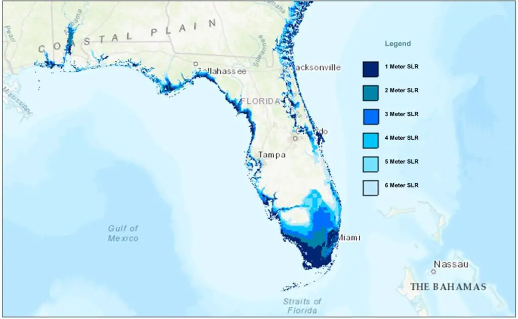
Florida Sea Level Rise Projections in Meters | Data Basin. Produced by the University of Florida Geoplan Center. These projections measure sea level rise in meter increments up until 6 meters, the predicted sea level rise measure if both Greenland and the West Antarctic ice sheet melt.
Scientists of the International Panel on Climate Change (IPCC) have used advanced geo-prediction software to monitor and predict rising sea levels around the world. The IPCC has provided two possible predictions for Florida depending on the extent to which climate change is controlled.
If we continue to use fossil fuels the way we do now, scientists predict a 53-98 cm (1.7-3.2 feet) increase in sea levels by 2100, which would flood half of Florida (up to Fort Lauderdale).
Even if we adopt stringent emission laws, we might see a rise of 28-61cm (0.9-2.0 feet). This would lead to one-quarter of Florida being submerged underwater by 2100. This also puts islands near the state at risk of flooding.
The Miami Herald published a NASA-approved map (Miami Herald subscription required) of what Florida could look like if sea levels rose by 5 meters. Miami, the Everglades, and the Florida Keys would be submerged according to these predictions.
You can now use this interactive map to check if your road will be flooded by 2040 or 2060 because of sea-level rise.
What is the government doing about sea level rise – In Florida?
Tackling government regulations about the rising sea level is tricky since different funds have been allocated to different cities. City funding is barely enough to cover damages, much less any proactive plans for construction.
Of all the states, Florida is predicted to have the highest costs to build structures to protect against rising seas, at a whopping USD $75 billion. This is twice the amount needed for number two on the list, Louisiana.
To prevent flooding, one-way flex valves have been built in Miami to make sure that the floodwater is not redirected inside the city. High-powered pumps have been sanctioned to pump water out of city areas. USD $40.9 million has been spent elevating roads, putting in drains, and fixing pumps.
However, a report by CNN shows that the system of building canals or pumps may not work well for too long, because most of Florida’s coast is built on an underlying coral reef. Miami, for example, sits on an ancient coral reef with limestone underneath. Since limestone is porous and prone to underground ‘pipe’ formations, the water may ultimately bubble up to the surface after a tipping point has been reached.
The most important legislation is that of building regulations; buildings must be constructed on higher ground so that low-level areas can be easily evacuated.
How global warming affects sea levels
After looking at Florida in particular, let’s understand how sea levels rise in the first place.
The more greenhouse gases are emitted, the warmer the earth gets. The warmer it gets, the more ice that melts and the more the oceans expand.
Sea levels are committed to rise for at least the next century.
Ice Melting
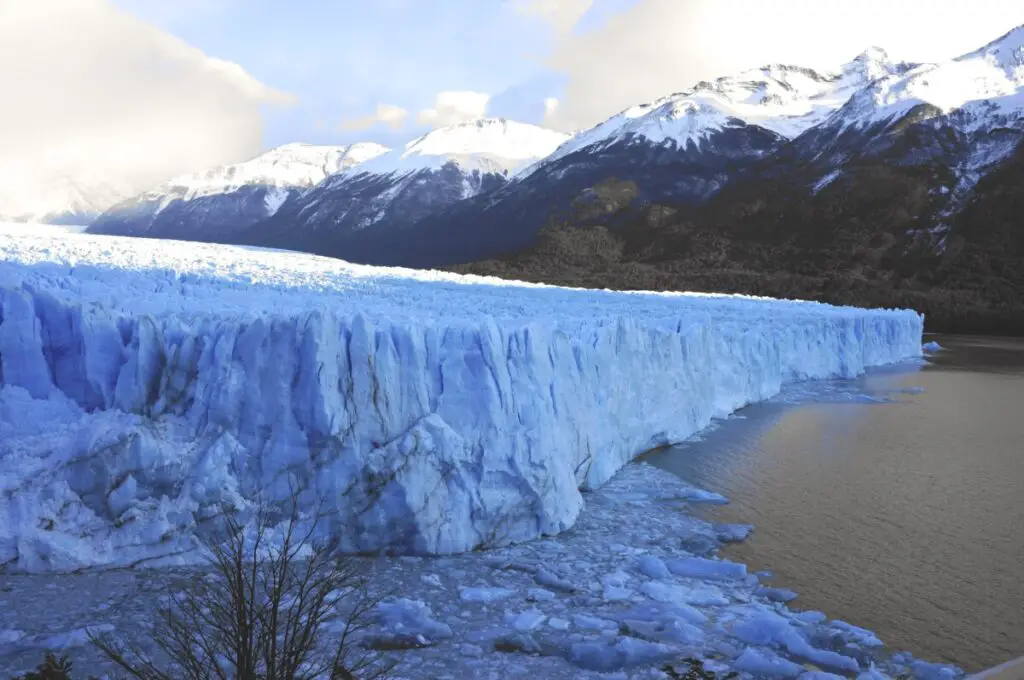
As the temperature of the earth increases, melting of ice introduces new water into the oceans.
Significant ice melting is already occurring in Greenland.
Over the last two decades, huge glaciers the size of multiple football fields have broken off from the ice shelf in Greenland. One of the most recent breaks was a glacier twice the size of Manhattan, as covered in a Bloomberg article. Such breaks lead to a domino effect – the more the ice shelf breaks, the easier it is for the glaciers that feed into the ice shelf to speed up and begin flowing faster into the sea.
A Guardian report states that huge chunks of glaciers are falling off the land of Greenland into the ocean, causing earthquakes and imminent rises in the sea level. When new water enters the ocean, the sea level increases, which leads to flooding.
According to the latest UN’s Intergovernmental Panel on Climate Change Sixth Assessment Report, the Greenland Ice Sheet is expected to continue to lose ice over the next 100 years regardless of what we do.
The greenhouse gasses already in the climate system are expected to cause ice loss from the Greenland Ice Sheet alone equal to 28 and 55 cm (11-22 inches) of sea level rise by 2100. However, the IPCC’s report also stated that increases of 2 metres by 2100 “cannot be ruled out”.
Ice Sheets, Glaciers, and Ice Caps
Most of the ice on earth (99.5 %) is locked up in ice sheets and glaciers.
The Antarctic and Greenland Ice sheets are the only two masses of land ice greater than 50,000 square kilometres (19,000 square miles) on the planet. In comparison, glaciers are essentially very slow moving rivers of ice and there are an estimated 198,000 of them found worldwide.
Ice sheets and glaciers rest on land, so as they melt or flow into the sea they contribute to the global sea level rise budget.
The bulk of earth’s ice is found in the southern hemisphere’s Antarctic Ice Sheet, which covers 8.3% of the earth and could raise global sea levels by nearly 58 m (190 feet) on full melting.
In the northern hemisphere, most of the ice is found in the Greenland Ice Sheet, which covers 1.2% of the earth’s surface and would raise sea levels by nearly 7.5 m (24.5 feet) on full melting.
Glaciers, including ice caps, cover 0.5% of the earth’s surface and could cause up to 0.32 m (1 foot) of sea level rise.
Like glaciers, Ice Caps are found all over the world, but in high-latitude regions they are called polar ice caps. Ice caps are masses of land ice covering less than 50,000 square kilometres (19,000 square miles) that typically feed a number of outward flowing peripheral glaciers.
Ice sheets, glaciers, and ice caps are already melting. Many glaciers and ice caps have entirely disappeared.
Permafrost, Sea Ice, Ice Shelves, Ice Streams, and Icebergs
Permafrost (frozen ground) also holds some stored ice and is common in parts of Siberia, Alaska, Canadian Arctic, and the Tibetan Plateau. The melting of permafrost is of little concern for sea level rise.
Of greater concern is permafrost contains vast amounts of stored methane, a highly potent greenhouse gas. Methane is more than 80 times more effective at trapping heat on earth than carbon dioxide, over a 20 year time scale. The melting of the worlds permafrost is considered a ticking methane time-bomb if it gets released.
Sea ice is frozen sea water. It is normal for sea ice to partially melt in summer and refreeze in winter. The volume of sea ice that melts and freezes is relatively balanced (no new melt during each summer cycle) and would not raise sea levels on full melting as they are already floating in the sea.
Unfortunately, a recent Nature Climate Change study showed summer Arctic sea ice is expected to completely disappear by 2035, something scientists previously didn’t expect until around 2050.
Ice shelves are floating outward extensions of glaciers and Ice Streams (faster moving section of a glacier/branched-valley glacier confluence) that originated on land. Because ice shelves are already floating, they do not directly raise sea levels as they break up and calve off Icebergs. However, ice shelves act like giant plugs holding back the glaciers and ice streams from flowing out to sea. Research suggests that ice shelf collapse can accelerate glacial flows by as much as six times, which will directly contribute to further sea level rise.
Human-induced global warming has significantly increased the amount of ice that is being lost from permafrost, glaciers, ice shelves, and extent of summer sea ice.
Ocean warming
Water expands when heated. About half of the sea level rise experienced over the last 25 years is because of the thermal expansion of the oceans as they take on more heat from the climate system.
Recent studies estimate the oceans have absorbed more than 93 percent of the heat that has already been created by excess greenhouse gasses over the past 50 years. Around 63 percent of this heat is now stored in the oceans from 0-700 meters (0-2,300 feet) deep, and 30 percent is in the deep ocean.
To put this in perspective, the remaining 7 percent of human-induced heat has gone to the melting of ice, snow and warming of the atmosphere and land surface. Eventually, the oceans will no long be able to take on more heat, at which point the warming of the planet’s atmosphere and surface will accelerate.
We have so far been buffered from the full effects of climate change by the oceans.
The bottom line
While current trends look grim, the future need not be as bleak. Taking proactive measures now may minimize damage and bring about sustainable changes. Reducing carbon emissions and promoting green legislation (like the Paris Climate Accord) are ways to combat climate change and manage rising sea levels.
References
Scambos, T. A., J. A. Bohlander, C. A. Shuman, and P. Skvarca. 2004. Glacier acceleration and thinning after ice shelf collapse in the Larsen B embayment, Antarctica. Geophysical Research Letters. <https://doi.org/10.1029/2004GL020670>
Guarino, M.V., Sime, L.C., Schröeder, D., Malmierca-Vallet, I., Rosenblum, E., Ringer, M., Ridley, J., Feltham, D., Bitz, C., Steig, E.J. and Wolff, E., 2020. Sea-ice-free Arctic during the Last Interglacial supports fast future loss. Nature Climate Change, 10(10), pp.928-932. <https://doi.org/10.1038/s41558-020-0865-2>
Rhein, M., S.R. Rintoul, S. Aoki, E. Campos, D. Chambers, R.A. Feely, S. Gulev, G.C. Johnson, S.A. Josey, A. Kostianoy, C. Mauritzen, D. Roemmich, L.D. Talley and F. Wang, 2013: Observations: Ocean. In: Climate Change 2013: The Physical Science Basis. Contribution of Working Group I to the Fifth Assessment Report of the Intergovernmental Panel on Climate Change [Stocker, T.F., D. Qin, G.-K. Plattner, M. Tignor, S.K. Allen, J. Boschung, A. Nauels, Y. Xia, V. Bex and P.M. Midgley (eds.)]. Cambridge University Press, Cambridge, United Kingdom and New York, NY, USA. <WG1AR5_Chapter03_FINAL.pdf (climatechange2013.org)>
Guarino, MV., Sime, L.C., Schröeder, D. et al. Sea-ice-free Arctic during the Last Interglacial supports fast future loss. Nat. Clim. Chang. 10, 928–932 (2020). <https://doi.org/10.1038/s41558-020-0865-2>